Updated on Aug 9, 07:30 PM: Karnataka CM has confirmed that water discharge from Almatti Dam has been increased to 4,80,000 cusecs. For the first time in history, the dam's outflow has superseded the inflow of 4,50,000 cusecs.
Updated on Aug 9, 6:00 PM: Schools and colleges in in 18 districts have been declared closed till 15 August in Dakshina Kannada,
Uttar Kannada, Raichur, Bagalkot, Belagavi, Chikkodi, Shivamogga, Bidar, Haveri, Kodagu, Koppal, Yadgir, Kalaburgi, Dharwad, Ballari, Hassan, Udupi and Gadag districts.
Updated on Aug 9, 5:55 PM: Incessant rain has led to flooding on Shivamogga - Chitradurga Road
Updated on Aug 9, 4:20 PM: Four bodies recovered by the rescue team after a landslide in Kodagu
Updated on Aug 9, 3:20 PM: Two people have died in a landslide near Bhagamandala, three people are also missing. Meanwhile, 2,136 people are taking shelter in 25 relief camps across Kodagu.
Updated on Aug 9, 2:55 PM: The rescue teams are now moving people from flood-affected areas to safety in Gokak taluk, Belgaum district.
Updated on Aug 9, 02:20 PM: Death toll rises to 11; over 1.24 lakh people evacuated
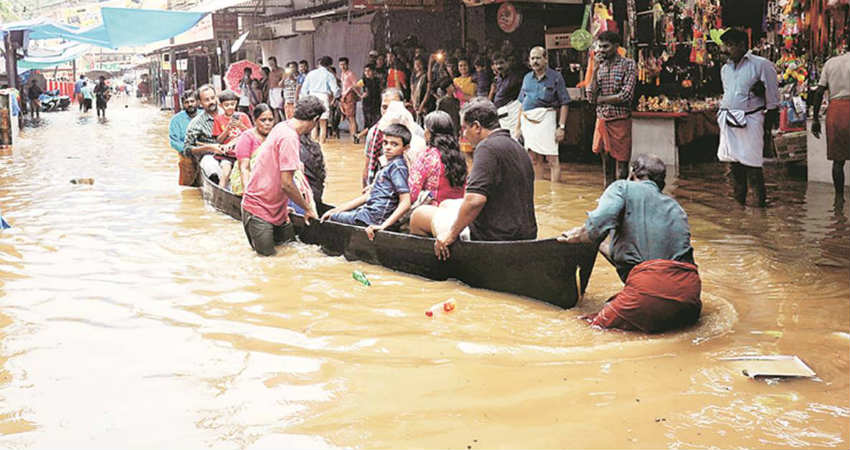
Published on Aug 8, 2019: Vigorous Monsoon conditions have given incessant rains over the coastal and northern districts of Karnataka. Torrential rains for the past 2-3 days have triggered floods in around 11 districts of the state.
Monsoon rains have wreaked havoc and so far have claimed seven lives. Normal life has come to an halt, with almost 26 state and national highways being shut.
Belgaum, Bijapur, Belagavi, Kodagu, Shimoga and Gadarpur are are some of the worst sufferers of the floods. Particularly, Belgaum that has been sharing border with South Maharashtra which has also been recording exceptionally heavy rains. The city has recorded 515 mm of rains for last three days i.e. August 6 recorded 158 mm, August 7 saw 170 mm and August 8 received 187 mm.
In fact, coastal stations of Mangaluru, Karwar and Honavar have also been receiving extremely heavy rains.
In wake of these extremely heavy rains, all the water bodies be it lakes, rivers or dams have reached to their peak, with some over flowing as well. State authorities of Maharashtra have also released water, making flood situation grim for Karnataka.
Weathermen are predicting critical times ahead as heavy rains would continue for next 2-3 days. The depression is seen over central parts of Madhya Pradesh and adjoining areas of Maharashtra. It has also kept the off- shore trough along the West Coast active along with strong winds from Arabian Sea infusing strong Monsoon surge over Karnataka.
With the huge inflow of water, Kabini dam has almost reached 2281.5 feet against its capacity of 2284 feet. Reportedly, once falling short of water, Kabini Dam has released 40000 thousands cusec waters.

 Kerala floods have nearly visited the state once again after almost a year. Last year between August 8 to August 19, excess showers of rain were recorded but extremely torrential rains were seen between August 15 to August 16. On August 15 and August 16, very heavy rains of 775 mm and 915 mm, respectively were recorded. These rains were almost nine to ten times the normal value. It is considered to be the worst floods of Kerala after 1924 which are famously known as the Great Floods of Kerala.
Rainfall amounts in Kannur from 12:00 am until 8:00 am today
Kerala floods have nearly visited the state once again after almost a year. Last year between August 8 to August 19, excess showers of rain were recorded but extremely torrential rains were seen between August 15 to August 16. On August 15 and August 16, very heavy rains of 775 mm and 915 mm, respectively were recorded. These rains were almost nine to ten times the normal value. It is considered to be the worst floods of Kerala after 1924 which are famously known as the Great Floods of Kerala.
Rainfall amounts in Kannur from 12:00 am until 8:00 am today
 The catastrophic rains all across the state were very much anticipated. The northern districts of the state have witnessed more rains in comparison to the southern districts.
Rainfall amounts in Ernakulam from 12:00 am until 8:00 am today
The catastrophic rains all across the state were very much anticipated. The northern districts of the state have witnessed more rains in comparison to the southern districts.
Rainfall amounts in Ernakulam from 12:00 am until 8:00 am today
 Rainfall amounts in Malappuram from 12:00 am until 8:00 am today
 Last year in Kerala Floods, nearly 483 people lost their lives. Whereas, Kerala has witnessed the heaviest rains of this season which kicked off yesterday. In the wake of these torrential rains, nearly fourteen people have died. Gushing water bodies, catchment areas, dams, terrain, etc. all are contributing to these floods.
Rainfall amounts in Kasargod from 12:00 am until 8:00 am today
Last year in Kerala Floods, nearly 483 people lost their lives. Whereas, Kerala has witnessed the heaviest rains of this season which kicked off yesterday. In the wake of these torrential rains, nearly fourteen people have died. Gushing water bodies, catchment areas, dams, terrain, etc. all are contributing to these floods.
Rainfall amounts in Kasargod from 12:00 am until 8:00 am today
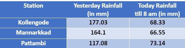
 Rainfall amounts in Palakkad from 12:00 am until 8:00 am today
 The rescue team is already out and is doing their job. Many institutions, the airport, schools have been shut in wake of these hefty rains. Until now, the Monsoon surge was active only over Konkan and Goa and parts of Karnataka. However, since the last two to three days, the Monsoon surge has been super active over Kerala. Moreover, a Cyclonic Circulation has developed over the southeast Arabian Sea off Kerala coast at mid-levels leading to hefty rains. Hence, the three-digit rains have been recorded at many places leading to widespread flooding.
Rainfall amounts in Kollam from 12:00 am until 8:00 am today
The rescue team is already out and is doing their job. Many institutions, the airport, schools have been shut in wake of these hefty rains. Until now, the Monsoon surge was active only over Konkan and Goa and parts of Karnataka. However, since the last two to three days, the Monsoon surge has been super active over Kerala. Moreover, a Cyclonic Circulation has developed over the southeast Arabian Sea off Kerala coast at mid-levels leading to hefty rains. Hence, the three-digit rains have been recorded at many places leading to widespread flooding.
Rainfall amounts in Kollam from 12:00 am until 8:00 am today
 Rainfall amounts in Thiruvananthapuram from 12:00 am until 8:00 am today
 As per our experts, these heavy rains would continue today as well over Kerala. Whereas by tomorrow the rainfall activities will start reducing and eventually there will be a gradual decrease. For the next 24 to 48 hours, rains activities will reduce but moderate showers with one or two heavy spells are expected. Therefore, no relief from ongoing flooding is foreseen. Palakkad, Malappuram, Kozhikode, Kottayam, Kollam, Kasaragod, Kannur, Ernakulam, and Thiruvananthapuram have been lashed by torrential rains in the past 24 to 48 hours.
Rainfall amounts in Kottayam from 12:00 am until 8:00 am today
As per our experts, these heavy rains would continue today as well over Kerala. Whereas by tomorrow the rainfall activities will start reducing and eventually there will be a gradual decrease. For the next 24 to 48 hours, rains activities will reduce but moderate showers with one or two heavy spells are expected. Therefore, no relief from ongoing flooding is foreseen. Palakkad, Malappuram, Kozhikode, Kottayam, Kollam, Kasaragod, Kannur, Ernakulam, and Thiruvananthapuram have been lashed by torrential rains in the past 24 to 48 hours.
Rainfall amounts in Kottayam from 12:00 am until 8:00 am today
 Rainfall amounts in Thrissur from 12:00 am until 8:00 am today
 The experts have to say that an Anti-Cyclone is likely to emerge soon in the southeastern parts of the Arabian Sea, in the vicinity of the Indian Ocean. The winds will once again change their course and will flow from the northwest direction. Thus, this would act as a saviour and rains will recede. By this time, next week, chances are very likely that minimal rains with the clear blue sky will be a sight.
Rainfall amounts in Kozhikode from 12:00 am until 8:00 am today
The experts have to say that an Anti-Cyclone is likely to emerge soon in the southeastern parts of the Arabian Sea, in the vicinity of the Indian Ocean. The winds will once again change their course and will flow from the northwest direction. Thus, this would act as a saviour and rains will recede. By this time, next week, chances are very likely that minimal rains with the clear blue sky will be a sight.
Rainfall amounts in Kozhikode from 12:00 am until 8:00 am today
 Image Credits – The Indian Express/ Skymet AWS Data
Any information taken from here should be credited to Skymet Weather
Image Credits – The Indian Express/ Skymet AWS Data
Any information taken from here should be credited to Skymet Weather

 गेल्या २४ तासांत बऱ्याच ठिकाणी मुसळधार पाऊस झाला आहे. विदर्भातील भागांत म्हणजेच नागपूर, ओकला, वर्धा, यवतमाळ आणि बुलडाणा मध्ये जोरदार पाऊस पडला आहे. तसेच, मध्य महाराष्ट्रातील भागात, कोल्हापूर, सांगली आणि सातारा येथे मुसळधार पावसामुळे पूर परिस्थिती निर्माण झाली आहे.
महाबळेश्वर मध्ये सर्वात जास्त पावसाची नोंद करण्यात आलेली आहे. येथे गेल्या २४ तासात, १६८ मिलीमीटर पाऊस झाला आहे.
गेल्या २४ तासांत बऱ्याच ठिकाणी मुसळधार पाऊस झाला आहे. विदर्भातील भागांत म्हणजेच नागपूर, ओकला, वर्धा, यवतमाळ आणि बुलडाणा मध्ये जोरदार पाऊस पडला आहे. तसेच, मध्य महाराष्ट्रातील भागात, कोल्हापूर, सांगली आणि सातारा येथे मुसळधार पावसामुळे पूर परिस्थिती निर्माण झाली आहे.
महाबळेश्वर मध्ये सर्वात जास्त पावसाची नोंद करण्यात आलेली आहे. येथे गेल्या २४ तासात, १६८ मिलीमीटर पाऊस झाला आहे.
 प्रतिमा क्रेडीट: विकिपीडिया
येथून घेतलेली कोणतीही माहितीचा क्रेडिट skymetweather.com ला द्यावे
प्रतिमा क्रेडीट: विकिपीडिया
येथून घेतलेली कोणतीही माहितीचा क्रेडिट skymetweather.com ला द्यावे


 The district collectors of Coimbatore and Nilgiris announced holiday for schools and colleges in the districts on Friday due to
 गेल्या अनेक दिवसांपासून मुसळधार पावसाने महाराष्ट्रात हाहाकार उडविला आहे. गेल्या ४८ तासांत विदर्भात जोरदार ते मुसळधार पाऊस पडला आहे. खरं तर, हा आत्तापर्यंतच्या मान्सून हंगामातील सर्वात मोठा पाऊस ठरला आहे.
स्कायमेटकडे उपलब्ध असलेल्या
गेल्या अनेक दिवसांपासून मुसळधार पावसाने महाराष्ट्रात हाहाकार उडविला आहे. गेल्या ४८ तासांत विदर्भात जोरदार ते मुसळधार पाऊस पडला आहे. खरं तर, हा आत्तापर्यंतच्या मान्सून हंगामातील सर्वात मोठा पाऊस ठरला आहे.
स्कायमेटकडे उपलब्ध असलेल्या 


 The United Nations Intergovernmental Panel on


 Yesterday heavy to very
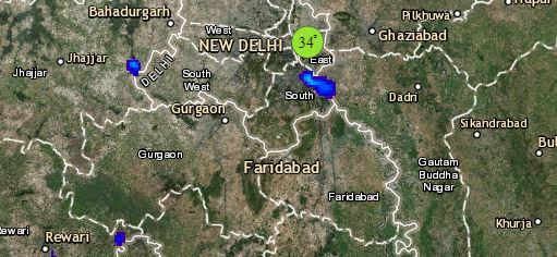
 At present, the Depression has weakened into a Well-Marked Low-Pressure Area and is presently lying over North Gujarat and adjoining Southeast Rajasthan. In the last 24 hours, heavy to